Grand West Baray: Man-Made Sea of the Khmer Empire in Angkor
Angkor Wat is, of course, the greatest monument of architecture and history, but far from the only outstanding object in the ancient capital of the Khmer Empire. In Angkor, there is a structure that is several times larger in area than the Ankgor-Wat complex, but few people know about it. Today we will talk about the largest reservoir in Cambodia. This is the Western Baray, located very close to the famous temple. Due to the busy excursion schedule, tourists rarely visit it.
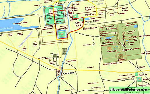
West Barai is a completely man-made reservoir of an amazingly regular rectangular shape with sides of 8 km to 2.1 km. This is the largest reservoir in modern Cambodia by area, which has been regularly performing its functions for more than 900 years. Its dimensions amaze and delight everyone who is lucky enough to be on its shores. And if for a moment we imagine that this reservoir was built not just by constructing a dam across the riverbed, but is the result of the work of the ancient Khmers, who manually excavated the soil and built a capacity of 5 meters deep, it becomes clear that we have before us the creation of a grand empire.

The Khmer Empire existed on the territory of the southern part of the Indochina Peninsula in the 9th-15th centuries. Its area was larger than the territory of modern Cambodia, and the capital was located in Angkor.

Western Barai was the most important link in the extensive irrigation network, which was built during the heyday of the empire, in the XI-XII centuries. According to historians, the construction of Baray coincides with the reign of King Suryavarman I and his successor, Udayadyavarman II. The empire's population reached several million people, so a well-organized farming system served the main economy and ensured the prosperity of the Khmer state. A whole complex of reservoirs was built in the country, which accumulated water during the rainy season and fed the rice fields with the necessary moisture during the drought period. Thanks to these facilities, it was possible to get 3 crops per year here. The grandiose Western Baray was the most important link in this system; water from it flowed into the regions located below.

The Western Barai is oriented strictly from west to east and is located west of the Angkor Thom temple complex. During a drought, the water level in the reservoir drops, and water is only in its western part. The shafts enclosing the reservoir along the perimeter have a width of up to 100 meters at the base and a maximum height of up to 20 meters. Typically, reservoirs are built by constructing a dam and further flooding the area lying upstream. In the case of the Western Baray, everything was completely wrong: it is surrounded by dams along the entire perimeter and is a completely man-made pool.
 Compared to the Western Baray, the grand temple complex of Angkor Wat looks very modest
But the Western Barai is not only an irrigation facility. In the center of the water, in the geometric center of the reservoir is the temple of Western Mebon. This circumstance speaks in favor of the fact that the reservoir could also have religious significance, symbolizing the Hindu world ocean surrounding the sacred mountain, in the role of which was the temple.
 Western Mebon
Western Mebon is square in shape with sides of 100 meters. It is partially destroyed, but nevertheless, three towers in the form of lotus buds and most of the eastern wall have been preserved here. It is also available for visiting tourists, but those who have allocated several days to visit Angkor and are not limited to a one-day trip to Angkor Wat often come here.
 Western Mebon
Interestingly, West Barai had almost the same grand twin brother. This reservoir is the Eastern Baray, which was also located in Angkor and was only slightly inferior in size to the Western Baray. Its width is 1.7 km and its length is 7.1 km. As historians suggest, it was built earlier, in the 9th century. In the center of this reservoir was located the temple of East Mebon. But today it is not used, the water has been drained, and from it there are only ramparts and a huge platform, which is clearly visible in space images. In the once grandiose reservoir, rice fields and houses of local residents are located.

Watch the video: Khmer Empire. Wikipedia audio article (April 2024).


-
Instagram of this 16 year old guy will make you pack your hiking backpack fast
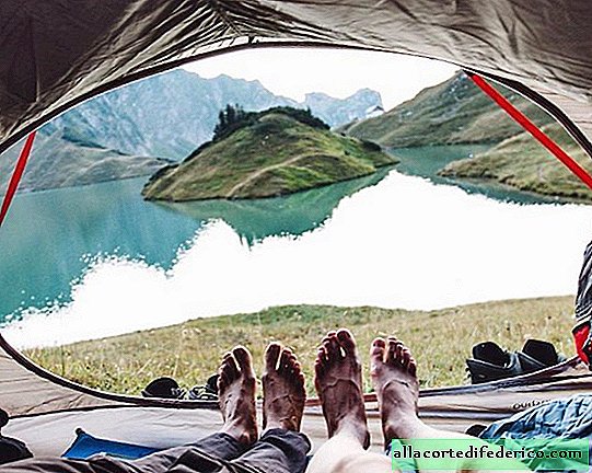
Yannick Aubenhoff is a 16-year-old novice landscape photographer. He lives in Germany - a country of dense forests, foggy mountain peaks and transparent blue lakes. Young talent always loved to spend time in the fresh air, and at the age of 13 he first began photographing majestic landscapes on camera. Now he enthusiastically continues to deal with this matter, in which he achieved quite impressive success: 200 thousand Instagram followers. ... -

-
-